 |
|
|
The
July 4th, 2001 Storm |

As we are all aware, Wednesday July 4th 2001 will be remembered by area CANWARN spotters and storm chasers as the day of the seven Tornados.
The Waterloo Region CANWARN net was active from shortly after 11:00 am until 8:00PM in the evening and saw a flurry of severe weather related activity as the net went from condition Green, to Yellow to Red as Tornadoes were touching down all around our VE3KSR CANWARN coverage area.
Ron VA3TVS
A few days after the storm I sat down with our CANWARN coordinator Ron Gravelle VA3TVS and interviewed him on the events leading up to and during the storms path through Southern Ontario.
As well, be sure to read the story filed with us by Storm Chaser Mark Robinson who was able to witness and tape on of the many tornados that touched down during the storm.
Paul

At noon on Tuesday July 3rd, the Storm Prediction Center in Norman Oklahoma had Southern Ontario under a slight risk of severe weather. Ron maintained a vigilant watch on this US based site and by late evening both the Norman OK and the Environment Canada web sites were showing risk of severe thunderstorms. Ron then started studying publicly available charted information from the University of Oklahoma, University of Chicago comparing airflow speed and direction at seven different levels in the atmosphere. Based on various wind directions at various heights Ron was able to get a feel for what type of weather may be approaching us here in Southern Ontario. By the wee hours of the morning Ron saw that all of the severe weather parameters were in place and Southern Ontario would be in for a "pretty good show" on Wednesday so Ron hit the sack about 4:30AM.
Rising shortly before 11am Ron scanned the radar images and could see
lots of storm scale rotation reaffirm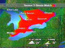 ing
his earlier predictions. The CANWARN pager brought Ron out from behind his
computer monitor at 11:05 AM and after a brief phone conversation with the
severe weather desk in Toronto Ron brought the Waterloo Regional CANWARN
net up in condition green at 11:15. Almost immediately Golf ball size hail
was reported by Dave Patrick east of Guelph and CANWARN spotters
reported hail in the Fairview Plaza area of Kitchener and very heavy rain
and hail North of Elmira. Ron immediately took the CANWARN net to
condition Yellow.
ing
his earlier predictions. The CANWARN pager brought Ron out from behind his
computer monitor at 11:05 AM and after a brief phone conversation with the
severe weather desk in Toronto Ron brought the Waterloo Regional CANWARN
net up in condition green at 11:15. Almost immediately Golf ball size hail
was reported by Dave Patrick east of Guelph and CANWARN spotters
reported hail in the Fairview Plaza area of Kitchener and very heavy rain
and hail North of Elmira. Ron immediately took the CANWARN net to
condition Yellow.
The Action Begins
About 2:30 PM Marg Verbeek, the Waterloo Region Emergency Planning
Coordinator, called Ron for a severe weather forecast. Ron indicated
that she was well aware of the situation but required a detailed storm
system analysis in order to alert regional emergency services.
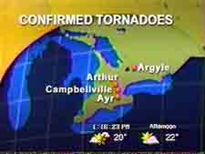
More heavy hail and flooded road reports streamed in from the Fergus and Elmira areas. Then about 2:45pm a Tornado was reported on the ground near Argyle Ontario followed by another citizens report of a funnel dropping from the sky near Arthur however due to trees there was no confirmation if it reached the ground.
Then multiple reports from spotters in the Ayr area just south of
Kitchener started coming in via 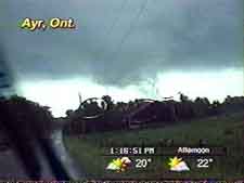 VE3KSR
and by phone from storm chaser Dave Patrick of Fergus who was shooting
video of the funnel (see his Weather Network image)
which did not reach the ground. Glenn VE3GCI who lives in Ayr was
also watching the tornado and reported his sighting to Ron at CANWARN Net
Control and Ron immediately took the net to condition Red.
VE3KSR
and by phone from storm chaser Dave Patrick of Fergus who was shooting
video of the funnel (see his Weather Network image)
which did not reach the ground. Glenn VE3GCI who lives in Ayr was
also watching the tornado and reported his sighting to Ron at CANWARN Net
Control and Ron immediately took the net to condition Red.
Following earlier discussions with Ron as to where a tornado was likely to develop, Dave was in the Ayr area . Ron's forecast was "right on" as Dave was able to confirm multiple vortices in this tornado as he followed it along it's path developing severe thunderstorms as it moved eastward before dissipating around St. George.
At this point the severe weather moved out of our area towards the east
and Ron returned the CANWARN net to condition green and started to relax
after a very long net operation when reaching for his Sprite the phone
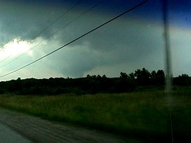
rang, it was Mark Robinson, screaming "Tornado on the ground!!"
"Tornado on the ground!!". A very excited Mark (this
was his first tornado sighting) grabbed his video camera and
capture the funnel on tape. (see video capture from Mark's tape
from The Weather Network) Fellow storm chaser Jack Kertzie
from Buffalo NY SKYWARN was also in the area and also captured the tornado
 as it moved along the
ground for some 20 minutes before dissipating as it dropped over the
Niagara escarpment. (see left image of Jacks video capture) A
security guard at Mohawk Raceway at Campbellville also spotted the funnel
and trained the remote security camera located high above the racetrack
grandstand on the Tornado and was able to capture it on tape as it moved
past the facility.
as it moved along the
ground for some 20 minutes before dissipating as it dropped over the
Niagara escarpment. (see left image of Jacks video capture) A
security guard at Mohawk Raceway at Campbellville also spotted the funnel
and trained the remote security camera located high above the racetrack
grandstand on the Tornado and was able to capture it on tape as it moved
past the facility.
Then it was over�. The skies cleared and Ron finally had a bite to eat and a chance for some rest.
Lessons Learned
1. Whenever the net is in condition Yellow, no one should report ANYTHING other than the following: * Rising scud into the clouds * Rotating wall clouds * Pea size or larger hail * Very high winds of sufficient strength to damage trees or buildings Extremely heavy rain
PLEASE - no reports like "it's raining here", "sky is quite black here" , "it's windy here" should be reported during condition Yellow or Red.
- A second person is definitely needed at Net Control to handle the radio traffic while the net is in condition Yellow or Red.
Thank You
Ron would like to personally thank the following spotters who
assisted during the July 4th CANWARN net.
| VE3EOS Gord | VE3OVO John | VA3NGN Jason |
| VE3YPN Jim | VA3EZT David | VA3MCK Bob |
| VA3GGS Glenn | VA3MW Mike | VE3NXD David |
| VE3GCI Glenn | VE3SY Paul | VA3BNY Ben |
| VA3NSV Terry | VE3OBP John | VE3SJV John |
| VE3MTQ Scott | VE3ABZ "AJ" | VA3DLT Dennis |
| VA3TPK John | VA3TV Ron | |
| and Storm Chasers David Patrick from Fergus, Mark Robinson from Mississauga and Jack Kurtzie from Buffalo all studying for their Ham Ticket so they can use ham radio next storm rather than their cell phones. | ||
Storm Log from Environment Canada
General weather statement issued by Environment Canada. Regional centre
Toronto Ontario. 10.03 pm EDT Wednesday 4 July 2001.
The following is a summary of the severe weather outbreak across southern Ontario on Wednesday July 4.
-
9:00 am Sarnia.. Marble-sized hail
-
11.15 am Elmira ..... Golf ball-sized hail
-
11:40 am Acton.....golf ball-sized hail
-
Cambridge ..(late morning).........golf ball-sized hail
-
12:00 pm Guelph....1.5 inch hail with 6 inch hail drifts along roads and local flooding
-
12:00 pm West Toronto.. Possible tornado in Mississauga
-
Fergus ..(early afternoon).........quarter sized hail
-
Elmira ..(early afternoon).........flooded roads
-
1:20pm Toronto island .. Hovercraft reported funnel cloud Toronto city centre airport..(1.20 pm)... 89 km/h wind gusts
-
2:00 pm Toronto city centre airport.. 31 mm rain in 1.5 hours
-
2:30pm near Bancroft...2.3 cm hail west of Bancroft near Highland Grove.. unconfirmed tornado with hydro poles and trees down
-
2:45pm Argyle ...Tornado reported
-
Regional rd 30 in Peterborough area.. (mid afternoon).. funnel cloud with barn roof lifted off...silo sheared off.
-
3:00 Sarnia ....marble-sized hail
-
3:10pm Sarnia ..trees and power lines downed quarter- sized hail
-
3:10 Barrie ....nickel-sized hail
-
3:30pm Petrolia ...strong rotation on Doppler radar but no confirmed tornado
-
4:00pm south of Lake Simcoe ...strong rotation on doppler radar with long-lived wall clouds associated
-
4:30pm Shelburne.....marble-sized hail
-
5:00pm Arthur.....tornado sighted
-
 5:00pm
Ayr (south of Cambridge) .. tornado sighted then lifted and touched
down again near St. George west of Hamilton
5:00pm
Ayr (south of Cambridge) .. tornado sighted then lifted and touched
down again near St. George west of Hamilton -
7:45 Campbellville/Milton....tornado spotted lifted partial roof off barn and downed numerous trees with debris tossed about reportedly 100 cars stopped on hwy 401 near Milton watching tornado
Video captures courtesy of the Weather Network
Storm Related Links
|
|
||
|
|
© 2003 |
|